

Mali, a landlocked country in West Africa, is about three times the size of Germany with an area of over 1.2 million square kilometers. Over 1,700 km along the north-south axis, Mali spans three climate and vegetation zones.
The north of Mali lies in the Sahara. It covers about a third of the country and is almost deserted. The old trading centers of Timbuktu and Gao are located on its southern border.
The central part of the country to the south, the Sahel region, covers another third and is characterized by dry steppe and thorny savannah. There are usually fewer than 10 inhabitants per square kilometer. The annual precipitation is between 700 and 1200 mm. The livelihood of the predominantly nomadic population is based on pasture farming; in the southern area, millet and sorghum are also cultivated, as well as shallots in Dogonland.
Most of Mali’s approximately 20 million inhabitants live in the more fertile southern third of the country: the wet savannah. All the typical crops of western Sudan are grown here.

The inland delta of the Niger lies in the middle of the country. Due to the floods of the Niger, the delta can expand to up to 20,000 km² between August and November and offers water-rich areas for post-flood crops such as sweet potatoes, beans and vegetables of all kinds, as well as for rice cultivation, in addition to grazing and fishing grounds. The Niger is Mali’s lifeline.
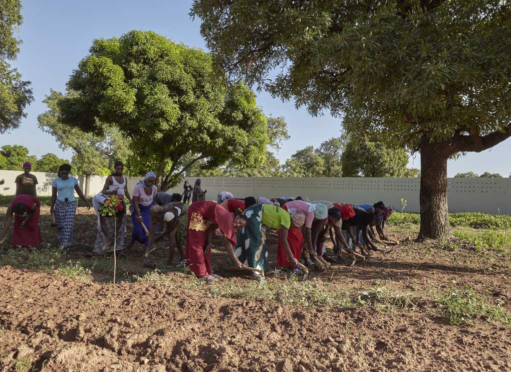
Despite explosive urbanization, the majority of people continue to work in agriculture. Rapid population growth, climate change and increasingly unpredictable rainfall, deforestation, droughts, dwindling soil fertility and poor seed reduce yields from agriculture. Rural poverty is increasing and causing rural exodus.
Mali has an almost monotonous flat relief. In some regions, however, there are remnants of old massifs and table mountains, such as the impressive Falaise in Dogonland or the Mandingoberge southwest of Bamako. The Centre Agro-Alimentaire Siby (CAAS) is located at the foot of these picturesque sandstone mountains near Kalassa.
The landlocked countries of the Sahel have considerable economic disadvantages compared to the coastal countries due to the distances to the seaports of West Africa. This also applies to Mali. Imports and exports are transported by road via Dakar (Senegal), Conakry (Guinea) or Abidjan (Ivory Coast). This is time-consuming and expensive. The rail link to Dakar has been at a standstill for years for technical and political reasons.
In 2020, a phase of democracy in Mali that lasted almost thirty years came to an end. The last elected regime of Ibrahim Boubacar Keita had triggered ongoing mass protests due to mismanagement. A military coup prevented a political overthrow. Since then, the new military regime has been talking about a phase of transition. Even after four years, there is no end in sight. Mali left the alliance of West African states (ECOWAS) in protest against its sanctions and joined forces with the military regimes in Burkina Faso and Niger to form the Alliance des États du Sahel (AES) in 2023.
The military regime wants to end the insecurity in the north and center of the country (caused by Tuareg separatists and Islamist jihadists) using military means alone. This is why it withdrew from the Algiers (peace) agreement (2015) at the beginning of 2024. Even before that, the regime had already got rid of both the UN mission and Western military aid, turning instead to Russia and the Wagner troops. Large parts of the country are outside the regime’s control. In the center of the country in particular, serious armed conflicts occur time and again. In the south of the country – where the CAAS is based – the situation is calm.
Current information
The country website of the German Federal Ministry for Economic Cooperation and Development (BMZ) provides a good overview of the current situation in Mali (in German).
The following English-language pages are concise, clear and up-to-date:
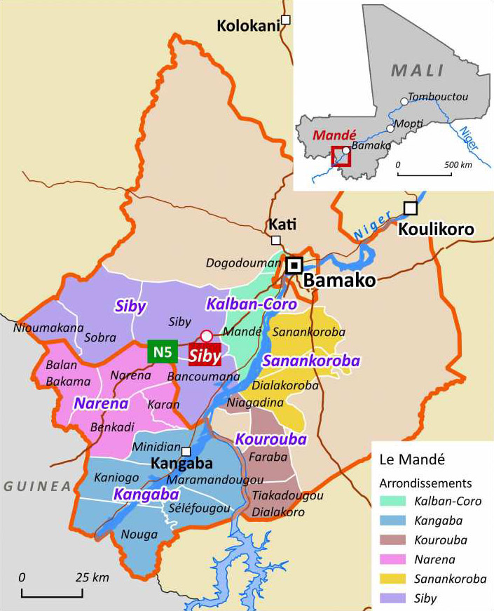
Location of the CAAS in Mandé
The CAAS is located on the outskirts of the small rural town of Siby in the neighboring village of Kalassa, 60 km southwest of the Malian capital Bamako. Siby belonged to the district of Kati until August 2024 and has since been promoted to the rank of a district town and thus the seat of a prefecture; part of the Koulikoro region.
Both places. Siby and Kalassa, are located in the historic region of Mandé . This actually comprises not only 20 rural communities in Mali (together 145 villages and a population of around 450,000 inhabitants), but a second, equally large part in Guinea. The population of Mandé consists mainly of Malinke and Bambara, two sedentary ethnic groups of arable farmers.
The construction of the highway to Guinea (Route Nationale No. 5), which was completed in 2011, has given Siby a new significance. The weekly Saturday market in Siby is by far the largest in the southwest of Bamako. Traders from Bamako flock here to buy mangoes, peanuts, charcoal and other items, depending on the season. On Saturdays, the population of Siby doubles or even triples. Many officials have secured early plots of land on the side of the road. Parts of the Route Nationale are developing into a long street village.
Since 2022, the road to Guinea has taken on a new importance for Mali. CEDEAO had imposed sanctions on the Malian junta and closed many borders to force them to return to constitutional order. Guinea, however, left its border open. The port of Conakry made it possible to circumvent the sanctions. Since then, traffic, including for military goods, has only increased.
In addition to Kalassa, the rural municipality of Siby comprises a further 20 villages and, according to the last census, a population of around 26,600. The commune is located in the plain south of the Mandingo Mountains, a mountain range of sandstone up to almost 500 meters high, which erosion has shaped into dramatic hills and cliffs.
Around 1,000 inhabitants live in the village of Kalassa in around 50 extended families of several generations. Many of the men have emigrated. Some have been working in Spain for years and only come home every few years. Today, young men are mainly drawn to the gold panning industry near Korémalé on the border with Guinea. The older men grow maize, millet and cotton next to their mango groves; the women near the farms mainly grow peanuts and some vegetables. They also collect shea nuts and keep some small livestock. Modernization has left almost no trace on the indigenous population. Rural poverty is palpable everywhere.